Welcome to
the Island of St. Martin & Sint Maarten in the Caribbean -
LukeTravels.com™
Main Page
 About the Island of St Martin - St. Maarten
Around the Island
The Beaches
How to get to St. Martin - St. Maarten
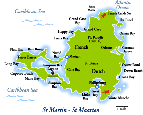
Map of the Island
Airfare & Hotel Info
Contact
Us
Advertise
Here
LukeTravels.com Home
Page
Amsterdam - Holland
Saba - Netherlands Antilles
St. Barth - French West
Indies
About the Island of St Martin - St. Maarten
Around the Island
The Beaches
How to get to St. Martin - St. Maarten
Map of the Island
Airfare & Hotel Info
Contact
Us
Advertise
Here
LukeTravels.com Home
Page
Amsterdam - Holland
Saba - Netherlands Antilles
St. Barth - French West
Indies
 St. Martin / St. Maarten: About the Island
 |
|
Saint Martin (Dutch: Sint Maarten) is a tropical island in the northeast Caribbean,
approximately 240 km (150 miles) east of Puerto Rico. The 87 km² island is
divided roughly in half between France and the Netherlands; it is the
smallest inhabited sea island divided between two nations.
The southern Dutch half comprises the Eilandgebied Sint Maarten (Island
area of Saint Martin) and is part of the Netherlands Antilles. The
northern French half comprises the Collectivité de Saint-Martin
(Collectivity of Saint Martin) and is a dependency of France.
The main towns are Philipsburg (Dutch side) and Marigot (French side).
The island has a total resident population above 71,000, divided
evenly between each half. Human density is three times that of
Holland. In addition there is an average of one million tourist
visitors per year. |
The highest hilltop is the
Pic Paradis (414 m) on center of an hill chain. There is no river on the
island, but a lot of dry guts. Hiking trails give access to the dry forest
covering tops and slopes.
The average yearly air temperature is 27 C (min 17 C, max 35 C) and sea
surface temperature 26.4 C. The total average yearly rainfall is 995 mm,
with 22 days of thunder.
No checkpoints or
noticeable boundaries exist between the Dutch and French sides of St.
Maarten/St. Martin. While families and friends live, work, play and travel
between the sides without giving it a second thought, each side proudly
offers a different landscape and cultural experience.¹
St. Martin / St. Maarten:
Political Status
France and the Netherlands agreed to
divide the island on March 23, 1648. To divide the island in two sections,
the inhabitants had to choose two walkers, one chosen by the
French-dominated community and the other one, named Menno Versteeg, by the
Dutch-dominated community, who were put back to back in one extreme of the
island, making them walk in opposite directions, and not allowing them to
run. The point where they eventually met was set as the other extreme of
the island, and the subsequently created line was chosen as the frontier,
dividing Saint-Martin from Sint Maarten. Seemingly, the French walker had
traveled further than the Dutch walker. According to tradition, the French
walker drank wine beforehand, while the Dutch walker drank beer. Some
people of the French section claim that the restorative effects of the
wine are the cause of their representative's longer walk, while some in
the Dutch section accuse the French walker of having run.
| Sint Maarten is officially an "island territory" part of the Netherlands
Antilles, which is part of the Kingdom of the Netherlands though not in
the European Union. Its currency is the Antillean guilder (however, the
United States dollar is widely accepted).
A planned restructuring of the
Netherlands Antilles would see Sint Maarten become an independent
component of the Kingdom of the Netherlands in its own right, possibly as
early as summer of 2007.
Saint-Martin is a French commune
forming part of Guadeloupe, which is an overseas region and overseas
department of France and is therefore in the European Union. |
|
|
The official currency in Saint-Martin is the
Euro (though
the U.S. dollar is also widely accepted). In 2003 the population of the
French part voted in favor of secession from Guadeloupe to form a separate
overseas collectivity of France; this has yet to be implemented.
Photo
Copyright ©
Tripadvisor.com and its authors
The French commune of Saint-Martin is governed by a mayor and a municipal
council elected by the European citizens living on the French side of the
island. As is the case in metropolitan France since the promulgation of
the Maastricht Treaty, nationals of any member state of the European Union
are allowed to vote at the municipal elections. Nationals from countries
not part of the European Union, which represent a large part of the
population on the French side of the island, are not allowed to vote in
the elections.
The Dutch island territory of Sint Maarten is ruled by an island council,
an executive council, and a governor appointed by the Dutch Crown.¹
St. Martin / St. Maarten:
Touring Philipsburg
To feel the pulse of St. Maarten, you must walk the narrow streets and alleyways of
Philipsburg, stopping to gaze at the array of merchandise featured in store windows or the
colorful paintings adorning gallery walls. You must take a moment to study the
architectural details of the old buildings that line Front Street. And you must listen to
the carnival rhythms blaring from open storefronts as traffic hums in the background.
After absorbing the sights and sounds of this thriving capital, you can head to the hills
and discover another side of St. Maarten. Great Bay is aptly named as it is the largest
bay on the entire island.
St. Martin / St.
Maarten:
Philipsburg
The heart of Philipsburg, and the center of its tourist activity, is a thin stretch of
land, only a few blocks wide, that stretches for about a mile between Great Bay and the
Great Salt Pond. Its two main thoroughfares, Front Street and Back Street (called
Voorstraat and Achterstraat in Dutch), are connected by little alleys (steegjes) with
Dutch names recalling the street signs in Amsterdam. Lining the two main arteries are
colorful shops, modern hotels and domestic dwellings, as well as some renovated older
buildings that still retain their distinctive West Indian gingerbread, or fretwork,
ornamentation.
In the heart of Philipsburg is Wathey Square, a bustling center of activity filled with
taxis, vans, peddlers and pedestrians. Just off the square is the renovated Captain Hodge
Wharf. The pier, with its gingerbread detailing, is where cruise passengers disembark to
spend the day on the island.
|
Across from the square is the courthouse. Originally built in 1793,
the beige-and-green structure has been renovated several times, most
recently in 1995.
It has housed the council hall, a weigh station, the post office, the
jail and a fire station.
Over the years, these various services expanded and moved to their own
quarters, and today the building is used exclusively by the court. |
|
|
Walking along Front Street, you'll realize why Philipsburg has become known as the
shopping mecca of the Caribbean. In one of the world's only 100% duty-free destinations,
visitors from around the globe discover an impressive array of stores offering the finest
in fragrances, fine jewelry and watches, liquor and tobacco, leather and accessories,
fashions, electronics and more at great savings.
Near the east end of Front Street is the historic Passangrahan Hotel. The oldest inn on
St. Maarten, it was once the Royal Guest House hosting such luminaries as Queen Wilhelmina
of the Netherlands. Its picturesque West Indian-style architecture and fragrant tropical
foliage impart the feeling of a bygone era.
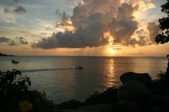
Photo Copyright
©
Tripadvisor.com and its authors
Closer to the end of Front Street, in a small bayside alley (Speetjens Arcade) at number
10, you'll find the two-story Sint Maarten Museum. The museum's objective is to reflect
the history and culture of the island and its people. On display are pre-Columbian relics
and artifacts from Fort Amsterdam and the shipwreck of the HMS Proselyte. You'll also see
stamps, coins and an array of household items. The museum shop offers books on island and
regional history, politics, nature and poetry, along with a selection of 17th- and
18th-century replica maps. There's also an array of unusual artwork, crafts and souvenirs
from the island, the Caribbean, Central and South America, and West Africa.
If you're fascinated with diving and maritime history, don't let the museum be your only
stop. Just around the corner on Front Street, inside the Last Mango in Paradise store, is
the HMS Proselyte Maritime Museum. On display here is a variety of artifacts, shipwreck
coins and more.
St. Martin / St. Maarten:
West from Philipsburg
At the far west end of Front Street, away from Philipsburg's commercial activity, is
Little Bay. Still standing on the narrow sliver of land between Little Bay and Great Bay
are the remains of Fort Amsterdam. Dating back more than 300 years, the fort was built by
the Dutch and stands on the foundation of an earlier Spanish fort. From here, you can also
see what was once the site of Fort Willem, directly north atop Fort Hill. From 1801 to
1848, this fort changed hands 16 times between Dutch, British and French powers; soon
thereafter it was abandoned.
At Orient Beach area on St.
Martin side of the island.
Photo Copyright ©
LukeTravels.com - Luke Handzlik - All Rights Reserved
You can reach Fort Amsterdam via the Little Bay Beach Resort. You can park near the tennis
court at the waterfront and walk through the resort, then up the hill. To get to Fort
Willem, drive up the road that begins opposite the entrance to the Great Bay Beach Hotel.
The upper road is unpaved, and the hill is very steep. There is little left of the fort,
but the view from here is magnificent.
Heading to the western end of Dutch St. Maarten, you'll cross over Cole Bay Hill. An
observation platform on top of the hill, just off A.J.C. Browers Road, offers a
spectacular view of Simpson Bay and, on a clear day, the neighboring islands of Anguilla,
Saba and St. Eustatius.
St. Martin / St. Maarten: Over the Hill to Marigot
| Once you've made it over
the hill, turn right at the stoplight for the most direct route to
Marigot. You will soon pass the Border Monument welcoming you to the
French side.
Erected in 1948, the monument
commemorates the friendly relations between the two nations that share
the island.
From there, you'll travel through the Bellevue area, a
stretch of rolling green hills with great lagoon views, before
reaching bustling, elegant Marigot.
|
|
 |
St. Martin / St. Maarten:
Over the Hill to Airport & Beaches
To make your way to the airport and beaches, turn to the left at the stoplight once you've
traveled over Cole Bay Hill. You'll reach the Simpson Bay area, where the Princess Juliana
Airport is nestled on a narrow strip of land between Simpson Bay and Simpson Bay Lagoon.
This area is popular for its many restaurants and nightlife. As you continue, you'll pass
three of Dutch St. Maarten's best beaches: Maho Beach, which lies at the foot of the
airport runway; Mullet Bay Beach; and Cupecoy Beach, considered by some to be one of the
most beautiful in the Caribbean.
Photo Copyright
©
Tripadvisor.com and its authors
For a peek at some remarkably different scenery, continue west and follow the signs to the
Terres Basses, or Lowlands. En route, the road passes through an area of heavy brush
growing out of the sand. This is the isthmus that separates Simpson Bay Lagoon from the
Atlantic Ocean. Passing across the sand spit, you'll enter the Terres Basses. This area of
exclusive villas lends a special atmosphere to the wonderful beaches found along this
portion of the island; Baie Rouge and Plum Bay are both local favorites. Beyond these
you'll find Long Bay, one of the island's most secluded beaches.
Keep going over the bridge and through the Sandy Ground area to complete the long and
scenic route to Marigot.
St. Martin / St. Maarten:
Marigot
Marigot is the kind of city made for lingering sipping coffee at a café with friends,
window shopping at a leisurely pace or strolling along the waterfront as the sun sets.
Located on the Baie de Marigot, the town is blessed with cool breezes that make it perfect
for outdoor activity.
During the day, the town is alive with the hustle and bustle of businessmen, shoppers and
tourists. When the sun goes down, however, Marigot takes on a different mood. Boats
returning from day excursions now bob in the bay. Couples walking hand-in-hand, families
pushing baby strollers and teens on skateboards roam the waterfront area. Music can be
heard coming from the crowded open-air cafés near the water. On the hill above, lights
illuminate Fort Marigot, adding a touch of magic to the French town below.
Fort Marigot on the French
side of the island
Photo Copyright
©
LukeTravels.com - Luke Handzlik - All Rights Reserved
To fully enjoy Marigot, come expecting to enjoy a leisurely lunch with a friend. Marigot's
bustling shopping and commerce comes to a virtual halt from around 1 p.m. to 3 p.m. daily,
ensuring a relaxing break for residents and visitors alike at any of the numerous outdoor
cafés and bistros. Don't miss Marina Port la Royale, a cozy marina lined on one side with
trendy French boutiques and on the other two sides with restaurants and sidewalk cafés.
A visit to Marigot is not complete without a visit to the outdoor market on the
waterfront. A combination craft, produce and fish market, it is in full swing early
Saturday morning. Women wearing brightly colored dresses tend makeshift stands piled high
with bananas, coconuts, mangos, pineapples and tubers. The rich aroma of spices emerges
from boxes filled with cinnamon sticks. Prices are set on fresh fish, fruits and
vegetables, but you can bargain for other goods.
High above the city's waterfront are the remains of Fort Marigot, formerly called Fort St.
Louis. The fortress was built in 1789 to protect the French from the British. It can
easily be reached on foot; from the waterfront tourist-information booth on Rue de la
République, a footpath leads up a hill to the street and on to the fort. Stone walls with
loopholes and a few cannons still face the bay. The view of Simpson Bay Lagoon and the
surrounding verdant hills and valleys is refreshingly beautiful.
|
A visit to the Saint-Martin Museum is a must. Its "On the Trail of the Arawaks"
exhibition features wonderful collections and photo displays with
particular attention given to various pre-Columbian treasures
discovered by the Hope Estate Archaeological Society. One of the most
impressive displays is the reproduction of a 1,500-year-old Amerindian
burial site discovered in 1994.
Among the other finds are various remains of indigenous inhabitants
dating back to 1800 B.C.; beautifully adorned ceramics from 550 B.C.;
and a selection of carved beads, pendants and amulets of stone and
shell. |
|
|
An exhibit on St. Martin's colonial history highlights the plantation and
slavery periods, while early-20th-century photographs of the island along
with historic maps and photographs depicting St. Martin's natural
environment are also on display.
Group tours of the museum are offered; guides speak English and French. The museum's gift
shop and second-floor art gallery feature local artwork, handicrafts and souvenirs. The
museum is open Monday through Saturday from 9 a.m. to 1 p.m. and from 3 p.m. to 7 p.m.